

It’s 698 miles (1123 km) from Carmel Valley, CA, to Flagstaff, and it’s a drive that Andrew and George Koch have done more than a few times for their redwoods projects; Carmel Valley has canyons where redwoods grow at the southern end of their range.
Highlights of the drive back to Flagstaff include the larger-than-life cutout figures near Salinas by local artist John Cerney , lunch at Taco Bros in Bakersfield, the Railroad Loop (not visible from the highway) at Tehachapi Pass, beautiful Barstow, the vast expanse of the Mojave Desert, crossing the Colorado River at Needles, CA—Topock, AZ, and slowly climbing back up to the Colorado Plateau around Kingman .
On a recent trip back from Santa Lucia Preserve, topics of discussion included: (1) what is the impact of a large solar farm on net radiation and partitioning the surface energy balance? (2) how does a wind farm affect local climate? (3) how is heat from a data center dissipated, and could it be used for domestic heating? and, driving through Barstow, (4) how hot will it be at the low point on the drive, crossing the Colorado River at an elevation of 429 ft (129 m)?
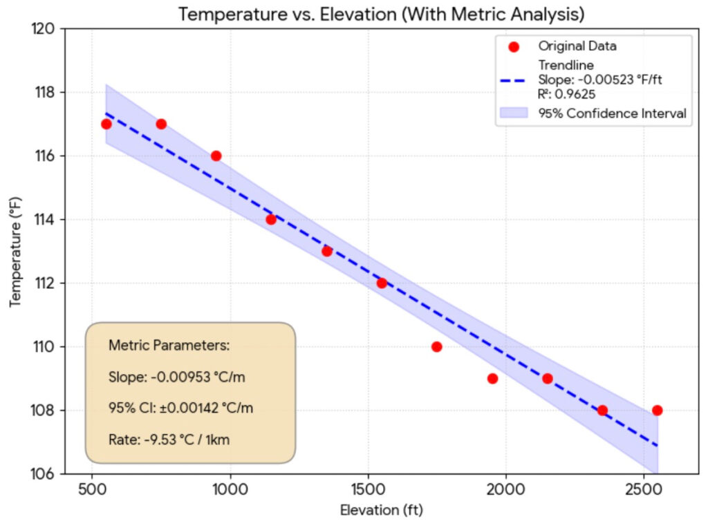
Question 4, in particular, led to some passenger-seat science! South of Mojave National Preserve, the I-40 reaches a maximum elevation of about 3300 ft (1000 m), opening up the possibility of a 2000+ ft (600 m) measurement transect. Using the temperature sensor in George’s Ford Maverick (reporting in °F) and the My Altitude app on Andrew’s iPhone, data on air temperature and elevation were recorded every 200 ft from just over 2500 ft down to about 500 ft.
Even with this primitive equipment, it was possible to come up with a pretty good estimate of the dry adiabatic lapse rate, typically accepted as 0.98°C per 100 m elevation. The plot below shows the data and calculated slopes in both meters and feet. The measured lapse rate of 0.95 °C per 100 m compares quite favorably with textbook values.
Bored on your next long drive? Think science!